An Indigenous-Led Environmental Data Management Platform
Project Overview
CoastViewer is a comprehensive environmental data management platform designed to support the critical stewardship work of Coastal Guardian Watchmen on BC’s North and Central Coast as well as Haida Gwaii. The platform connects to the Regional Monitoring System (RMS) database, empowering Guardians, stewardship officers, and community members with intuitive access to their nation’s environmental monitoring data through a user-friendly web interface.
The Challenge & Context
Coastal Guardian Watchmen play a critical role in monitoring and stewarding cultural and environmental resources in their territory. The Regional Monitoring System provides a standardized approach to collecting this data across the region, but accessing this valuable data previously required technical database skills that created barriers for Guardians, stewardship officers and community members.
Indigenous Data Sovereignty & OCAP Principles
CoastViewer was built with OCAP (Ownership, Control, Access, Possession) principles at its foundation—a set of First Nations data governance standards that establish how Indigenous data should be collected, protected, used, and shared. The platform directly supports First Nations data sovereignty by ensuring nations have complete ownership and control over their environmental monitoring data, with the technical barriers removed that previously limited access to this critical information.
Key Features
Advanced Data Discovery & Visualization
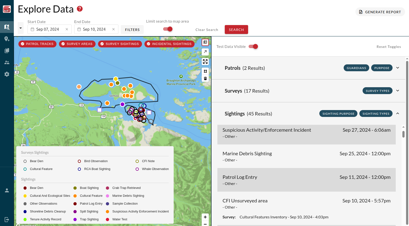
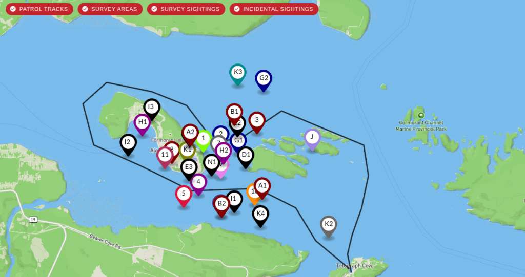
- Multi-filter search capabilities: Users can filter data by patrol dates, geographic locations, survey types, sighting types, guardians on patrol, patrol purposes, among other filtering parameters
- Dual presentation modes: Data is displayed both visually through interactive mapping and textually in structured lists
- Comprehensive patrol details: Full access to mapped geospatial data and all field data collected by Guardians
- Custom reporting: Users can generate summaries and reports based on search results
- Flexible data export: Multiple export formats support various analysis and reporting requirements
Data Management and Mapping
- Mapping: All geospatial data collected by Guardians is visualized on interactive maps using Mapbox GL JS
- Editing: Users can modify and update both geospatial and attribute data through mapping tools and graphical text editing interfaces
- Visual data validation: All data can be flagged by users for further quality assurance analysis, ensuring incorrect or missing data can be reviewed and corrected

Access Control & Security
- Granular permissions management: Administrative portal allows managers to control user access at detailed levels
- Community-controlled access: Nations maintain full authority over who can access their data and at what level
Development Journey
Legacy System Modernization
When I joined Coastal First Nations – Great Bear Initiative, I inherited a partially built platform that had been developed on Vue 2 several years earlier. By that time, the underlying technology stack had become outdated – Vue 2 was no longer supported, core libraries had been deprecated, and significant security vulnerabilities existed in outdated dependencies.
Complete Technical Overhaul
My first priority was a comprehensive modernization of the entire codebase:
- Framework migration: Transitioned from Vue 2 to Vue 3, requiring extensive refactoring across the entire application, including the replacement of any dependency that had no support for Vue 3
- Dependency updates: Upgraded all core libraries and resolved deprecated dependencies
- Security hardening: Addressed all identified vulnerabilities in the technology stack
Successful Launch & Ongoing Development
- MVP Launch: First version of the modernized CoastViewer launched successfully in February of 2024
- Iterative development: Regular feature releases based on community feedback and evolving needs
- Current status: Platform is in maintenance mode with ongoing feature additions as requested by First Nations communities and data analysts
Key Accomplishments
- Code Overhaul: Complete overhaul of outdated codebase to produce a modern and reliable application.
- Backend Performance Optimization: Initial code based made use of innefficient database queries and had poor management of connection pools. Through backend query optimization and improved management of connection pooling, I was able to reduce the time it took to pull patrol data by up to 90%. Considering most of the users live in rural and remote communities where internet is unreliable, this update drastically improved the experience for the app users.
- From monolith to modular: Original codebase also made use of large Vue components that violated the single responsibility principle, were slow to load and were difficult to maintain. Through the code overhaul and continued feature development, I broke many of these components into more modular components that led to smaller build files, improved frontend performance, as well as easier maintenance and future feature development.
Technical Implementation
Frontend Architecture
- Vue 3 frontend framework with Vuetify components based on Material Design principles
- Mapbox GL JS integration for professional-grade mapping capabilities for geospatial data visualization and interaction
- Responsive design platform works seamlessly across desktop and tablet devices
Backend Infrastructure
- Node.js server: Scalable backend built on Node.js runtime
- Express REST API: Well-structured API endpoints that facilitate data extraction and management
- PostgreSQL database: CoastViewer connects to the RMS database built on PSQL with POSTGIS extension
Impact & Significance
The Regional Monitoring Sytem, of which CoastViewer is a core component, represents a successful model of Indigenous-led technology development that prioritizes data sovereignty while delivering powerful technical capabilities. The platform supports the global movement toward Indigenous-led stewardship by ensuring that First Nations communities can effectively monitor and protect the cultural and natural resources of their territories using their own data on their own terms.
The RMS and CoastViewer demonstrates how modern web technologies can be thoughtfully applied to support Indigenous governance and environmental stewardship, creating tools that respect traditional knowledge systems while leveraging contemporary technical capabilities for maximum community benefit.
Special Thanks
I want to extend a big thanks to the Coastal Stewardship Network team at CFN, which gave an up-and-coming junior software developer the opportunity and support to take on such a big and fascinating project. Special thanks to Anton Pitts, who patiently helped me learn about mapping technologies, database management and environmental stewarship practices.